The Rural EV Charging Gap
EDK is a research lab focused on understanding the physical world at planetary scale. We build systems that organize the world's physical information and make it accessible and usable. Our belief is simple: the physical world should be as searchable and understandable as the digital world.
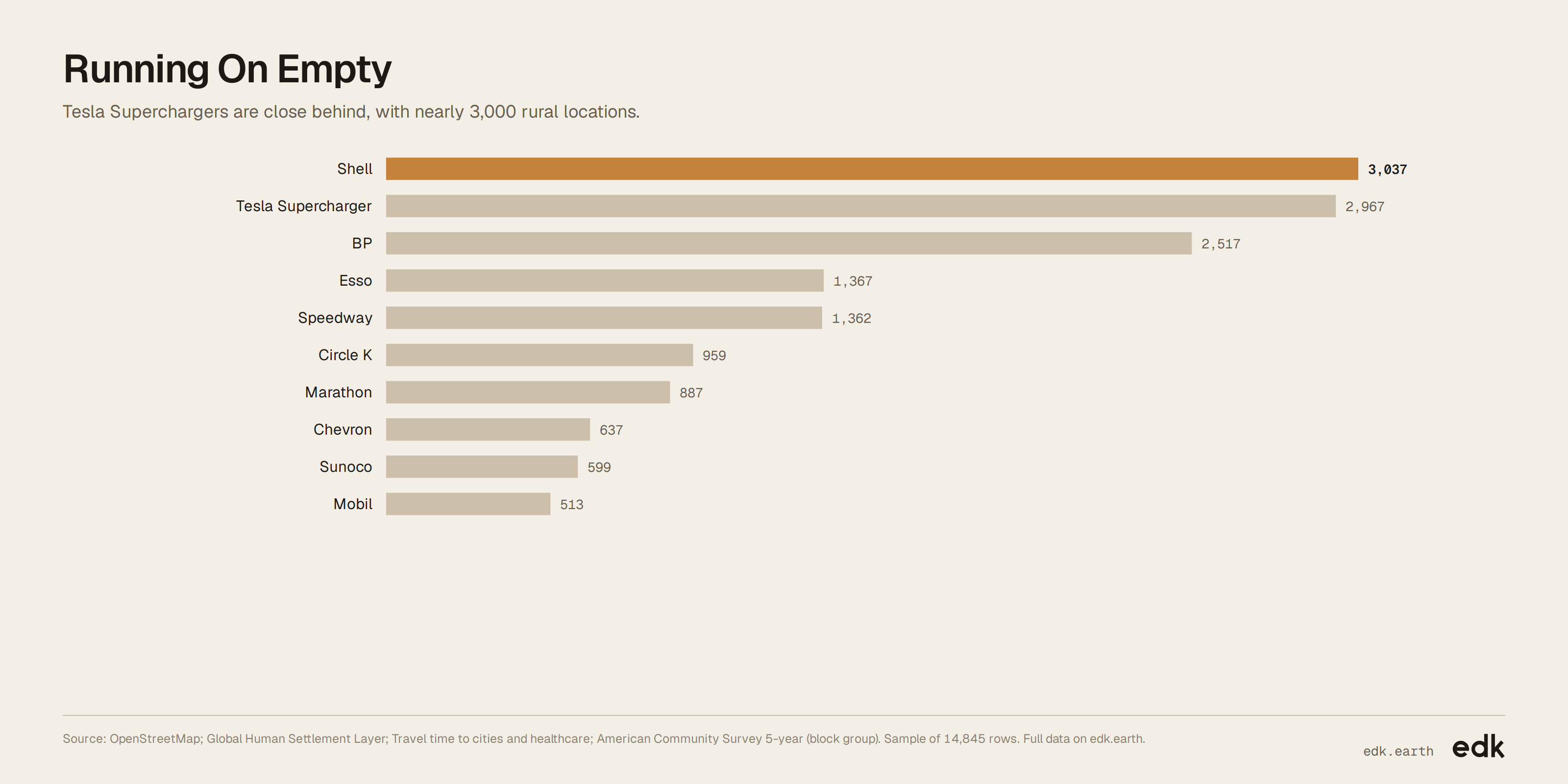
Rural Tesla Supercharger sites nearly match Shell, at about 3,000 each
A global view of rural charging and fuel sites, and the communities and landscapes around them.
Explore the full data
Every record EDK holds for this dataset. Filter it, then export what you need.
Loading…
Key findings
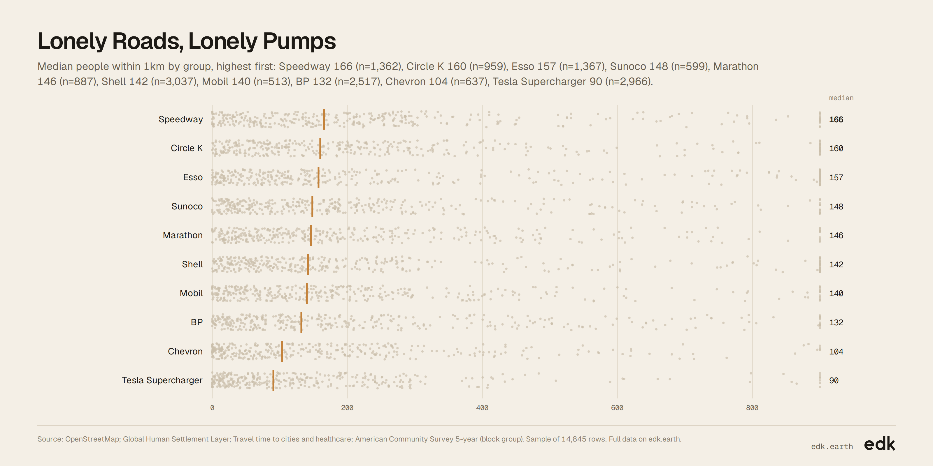
- The typical location has about 130 people living within a kilometre.
- The typical site is 27 minutes by car from the nearest city.
- Median solar potential is about 3.9 kWh per kW of panels per day.
About this dataset
Each entry marks a rural fuel-brand site or Tesla Supercharger and the surrounding community. Together, they show how these locations sit across population, household income, solar potential and distance from a city.
Use it for
- Transport planners: Compare rural charging locations with nearby population and travel times.
- Energy analysts: Assess where rural sites combine strong solar potential with low nearby population.
- Market researchers: Compare the rural footprints of Tesla and major fuel brands.
- Local governments: Identify rural areas where charging access may merit closer study.
Questions to explore
- Which brands have the largest rural footprints?
- Where are rural charging sites farthest from a city?
- Which rural locations pair low nearby population with strong solar potential?
Columns
id- Sequential identifier for an entry; no physical unit.
brand- Name of the fuel brand or charging network; category, not a unit.
people_within_1km- Estimated residents in the surrounding 1 km cell, in people.
drive_minutes_to_city- Estimated driving time to the nearest city, in minutes.
median_income_usd- Median household income for the surrounding census block group, in U.S. dollars; available for U.S. locations.
solar_output_kwh_per_kw_day- Expected daily generation from 1 kW of solar panels, in kWh per kW per day.
city- Matched city or urban area name; a place label.
state- State or province name; a place label.
country- Country name; a place label.
latitude- North-south coordinate in degrees, using the WGS84 reference system.
longitude- East-west coordinate in degrees, using the WGS84 reference system.
Sources
- EDK-1 · EDK
- EDK's spatial model: matches every record to its place and joins the context around it.
- OpenStreetMap · OpenStreetMap contributors
- Locations and brand identities for fuel stations and charging sites (ODbL 1.0)
- Global Human Settlement Layer · European Commission JRC
- Population estimates around each location (See publisher)
- Travel time to cities and healthcare · Malaria Atlas Project
- Estimated travel time to the nearest city (See publisher)
- American Community Survey 5-year (block group) · US Census Bureau
- Median household income for U.S. census areas (See publisher)
- Global Solar Atlas · World Bank Group / Solargis
- Estimated solar power potential (See publisher)
Released under CC BY-SA 4.0. Credit "EDK (edk.earth)" and the sources, and share what you build from it under the same license.
Good to know
- Household income values cover U.S. locations only, so they do not support global comparisons.
- Travel-time estimates are missing for some locations; check extreme values before comparing sites.