Reservoirs in Dry Lands
EDK is a research lab focused on understanding the physical world at planetary scale. We build systems that organize the world's physical information and make it accessible and usable. Our belief is simple: the physical world should be as searchable and understandable as the digital world.
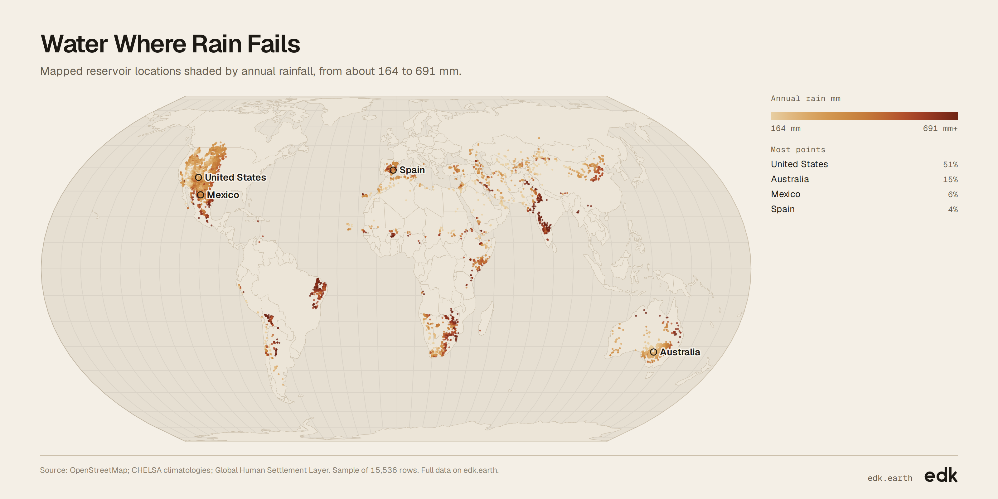
Half of mapped dry-land reservoirs are in the United States
A geographic look at mapped reservoirs and the climate and population around them.
Explore the full data
Every record EDK holds for this dataset. Filter it, then export what you need.
Loading…
Key findings
- About half of mapped reservoirs are in the United States; Australia accounts for about 15%.
- Annual rainfall at a typical mapped reservoir is about 363 mm.
- The typical mapped reservoir has no residents in its surrounding 1 km cell.
About this dataset
Each entry marks a named reservoir and describes its local climate and nearby population. Together, they show where mapped reservoirs sit across dry lands, and how rainfall, heat and nearby settlement vary.
Use it for
- Water planners: Compare reservoir locations with local rainfall and heat.
- Climate researchers: Explore how dry-land reservoirs are distributed across climates.
- Urban planners: Find reservoirs near population centres.
- Geospatial teams: Map reservoir locations and compare conditions across countries.
Questions to explore
- How does annual rainfall vary across mapped reservoirs?
- Which mapped reservoirs are closest to population centres?
- How do reservoir locations differ in temperature across countries?
Columns
id- A row identifier; no unit.
name- The reservoir name as published by the source; text.
annual_rain_mm- Annual precipitation at the location, in millimetres.
avg_temp_c- Mean annual air temperature at the location, in degrees Celsius.
people_within_1km- Estimated people in the surrounding 1 km cell in 2020; people.
city- The matched city name; text.
country- The country containing the location; text.
latitude- Latitude in the WGS84 coordinate system; degrees.
longitude- Longitude in the WGS84 coordinate system; degrees.
Sources
- EDK-1 · EDK
- EDK's spatial model: matches every record to its place and joins the context around it.
- OpenStreetMap · OpenStreetMap contributors
- Reservoir names and mapped locations (ODbL 1.0)
- CHELSA climatologies · WSL
- Annual rainfall and mean temperature (See publisher)
- Global Human Settlement Layer · European Commission JRC
- Population estimates around each location (See publisher)
Released under CC BY-SA 4.0. Credit "EDK (edk.earth)" and the sources, and share what you build from it under the same license.
Good to know
- Mapped locations reflect what has been recorded, not a complete inventory of reservoirs.
- Nearby population estimates cover the surrounding 1 km cell, not people using the reservoir.